< US 17 | Home | US 21 ALT | US 21 Bus | US 25 >
|
|
|
|
| ROUTE LOG |
S-7-406: 0 - 0 US 21 Bus, SC 802: 15.0 - 15.0 SC 281: 3.5 - 18.5 SC 128: 3.9 - 22.4 SC 170: 3.2 - 25.6 US 21 Bus: 1.4 - 27.0 SC 170: 1.1 - 28.1 SC 280: 1.0 - 29.1 SC 116: 1.4 - 30.5 US 17 NB: 9.7 - 40.2 US 17 SB, US 17 ALT Begin: 6.5 - 46.7 Hampton-Beaufort Line: 2.4 - 49.1 SC 68: 1.2 - 50.3 Colleton-Hampton Line: 2.2 - 52.5 US 17 ALT NB: 1.6 - 54.1 I-95 (exit 42): 2.4 - 56.5 SC 63: 10.0 - 66.5 SC 64: 6.4 - 72.9 SC 212: 5.0 - 77.9 SC 217: 3.6 - 81.5 Bamberg-Colleton Line: 6.1 - 87.6 SC 61: 0.1 - 87.7 Orangeburg-Bamberg Line: 0.1 - 87.8 US 78 WB: 5.4 - 93.2 US 78 EB: 0.3 - 93.5 SC 210: 0.4 - 93.9 US 21 Bus, US 178 EB, US 178 Bus: 15.1 - 109.0 US 301: 1.4 - 110.4 SC 33: 1.1 - 111.5 US 21 Bus, US 601: 0.8 - 112.3 US 178 WB: 1.0 - 113.3 Calhoun-Orangeburg Line: 7.2 - 120.5 SC 6 EB, SC 172: 4.6 - 125.1 SC 6 WB: 1.6 - 126.7 Lexington-Calhoun Line: 3.2 - 129.9 I-26 (exit 129): 1.7 - 131.6 Calhoun-Lexington Line: 1.1 - 132.7 US 176 EB: 2.1 - 134.8 Lexington-Calhoun Line: 6.1 - 140.9 I-26 (exit 119): 0.7 - 141.6 US 321 SB: 1.9 - 143.5 I-77: 3.0 - 146.5 I-26 (exit 115): 0.4 - 146.9 SC 2: 1.0 - 147.9 SC 302: 1.6 - 149.5 SC 35: 0.9 - 150.4 SC 2: 0.8 - 151.2 Richland-Lexington Line: 0.6 - 151.8 US 1, US 78: 1.0 - 152.8 SC 12: 0.4 - 153.2 I-126 Bus WB, US 76 WB: 0.5 - 153.7 SC 48: 0.6 - 154.3 I-126 Bus END, US 76 EB: 0.1 - 154.4 US 176 WB: 0.5 - 154.9 SC 16: 0.7 - 155.6 SC 215: 0.6 - 156.2 US 321 NB: 0.9 - 157.1 I-20 (exit 71): 2.6 - 159.7 I-77 (exit 34): 7.1 - 166.8 SC 555: 1.1 - 167.9 Fairfield-Richland Line: 4.5 - 172.4 SC 34: 4.4 - 176.8 SC 200 SB: 16.9 - 193.7 Chester-Fairfield Line: 0.2 - 193.9 SC 99: 2.8 - 196.7 SC 97 NB: 1.4 - 198.1 SC 97 SB, SC 200 NB: 0.2 - 198.3 SC 9: 7.3 - 205.6 SC 223: 5.2 - 210.8 York-Chester Line: 3.9 - 214.7 SC 5 EB: 3.8 - 218.5 I-77 (exit 73): 3.7 - 222.2 SC 5 WB: 0.7 - 222.9 SC 121 SB: 0.2 - 223.1 SC 122: 1.4 - 224.5 SC 121 END, SC 322: 2.7 - 227.2 I-77 (exit 82): 0.3 - 227.5 SC 161: 0.3 - 227.8 US 21 Bus: 1.4 - 229.2 SC 160: 2.1 - 231.3 SC 460: 2.8 - 234.1 US 21 Bus: 1.2 - 235.3 SC 51: 0.6 - 235.9 I-77 SB (exit 90): 0.3 - 236.2 NC STATE LINE: 0.9 - 237.1
|
Creation: Appeared in late 1926 as an original US highway. Began at US 17 (current US 17 ALT) near Yemassee, proceeding north with SC 301to Bells Crossroads; SC 6 to Orangeburg; SC 3 to St. Matthews and Columbia; SC 16 to Ridgeway, Winnsboro, and Chester; SC 7 to Rock Hill and Fort Mill before entering North Carolina heading towards Pineville, NC.
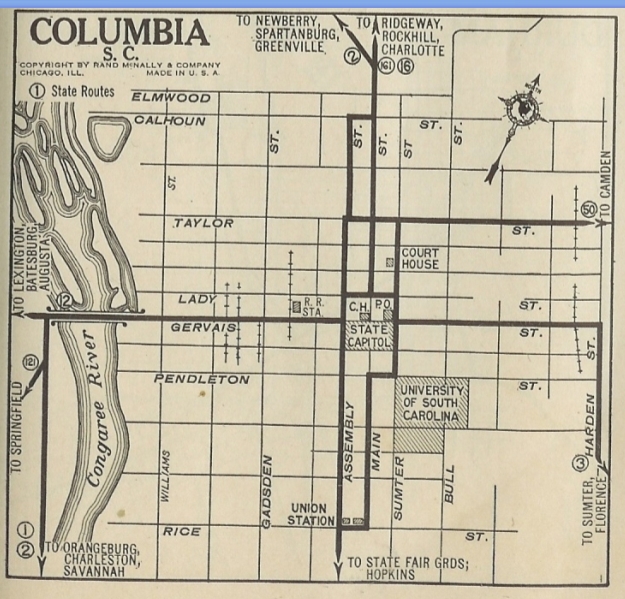
| Adjustments: In 1928, all the South Carolina routes were dropped from US 21 except SC 2. By 1929, US 21 was removed from S-12-709 Old Columbia Rd south of Chester. By 1931, US 21 was removed from S-20-44 and S-20-26 through White Oak. Between 1926-32, SC 2 was rerouted in Columbia from Gervais-Assembly-Calhoun-Main to instead use Gervais-Assembly-Taylor-Main
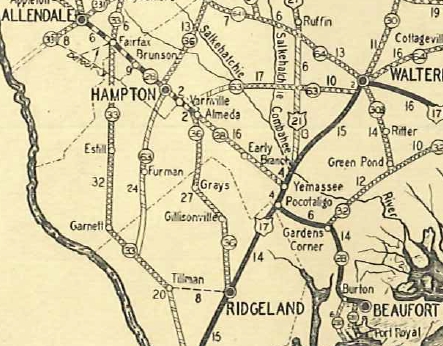
By 1932, US 21 was removed from S-20-256 and S-20-178 west of Ridgeway. Also, if US 21 ever used S-38-21 and S-38-117 from Rowesville south to Branchville it stopped by 1932. In 1933, US 21 was given a bypass of Cayce, leaving behind US 2 In 1935, US 21 was extended south with US 17 to Pocotaligo, then replaced SC 28 to Gardens Corner and Beaufort. It is not clear where in Beaufort US 21 ended but it may have been extended across the 1920s bridge to Ladys Island.
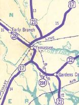
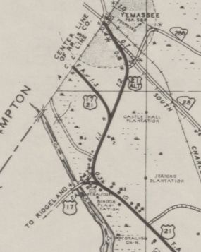
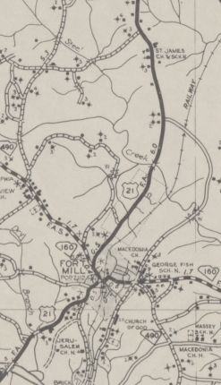
By 1938, US 21 was removed from Charlotte St in Rock Hill and placed on Oakland Ave instead. In 1938, US 21 was given a bypass around central Yemassee, leaving behind US 21 ALT. Today it is S-7-3 and S-25-1.
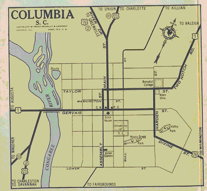
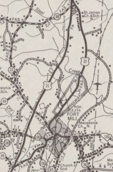
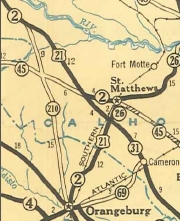
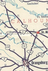
Also about 1938, US 21 was removed from St. Matthews by instead replacing the last bit of SC 31, leaving behind SC 6 and SC 26 (now US 601). By 1940, US 21 was placed on a bypass of Ridgeway, leaving behind what was almost certainly US 21 ALT Dogwood Ave (now S-20-9 and part of SC 34). About 1940, US 21 was rerouted in Columbia to run from Gervais-Assembly-Taylor-Main to instead use Gervais-Main. In 1947, SC 2 was removed from US 21. In 1948, US 21 was moved from St Matthews Rd and Boulevard St to Magnolia Rd in Orangeburg. Magnolia Rd had been US 21 ALT. St Matthews Rd became S-38-94 and Boulevard St became an extended SC 210 ALT (now S-38-25). Between 1943-48, US 21 was rerouted in Columbia from Gervais-Main to Gervais-Assembly-Elmwood-Main. In 1948, US 21 was given its bypass of Fort Mill, leaving behind US 21 Business.
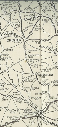
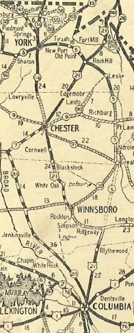
In 1950, US 21 was given a direct route from Ridgeway to Rockville via Great Falls and Fort Lawn, replacing SC 5. Ridgeway to Winnsboro became SC 213; Winnsboro to Chester became US 321; Chester to Rock Hill became SC 72. Today this is SC 34; Columbia Rd and US 321 Bus through Winnsboro; US 321; S-20-130 and S-12-130 through Blackstock; US 321; US 321 Bus into Chester; S-20-275 Saluda St out of Chester; SC 72 to Rock Hill
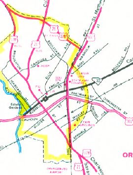
Also in 1950, US 21 was given a direct routing from Sandy Run south Orangeburg, replacing SC 210 to Chestnut St Orangeburg, then following Chestnut east as an upgrade to S-38-55 over to Magnolia to meet back up with US 21. The old route became SC 31 (now US 176) from Sandy Run to St Matthews area, then SC 26 (now US 601) to Orangeburg.
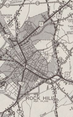
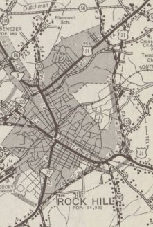
In 1953, US 21 was given its bypass of Rock Hill, which was a replacement of US 21 ALT. The route through Rock Hill became US 21 Business (now S-46-118 Black St, S-46-115 Oakland Ave, SC 322).
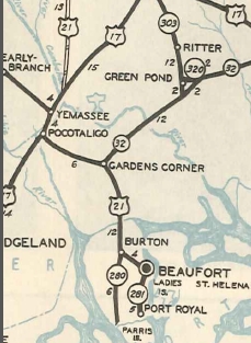
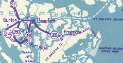
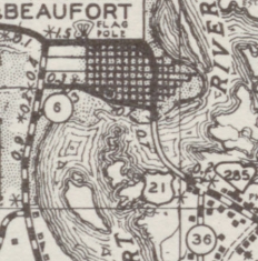
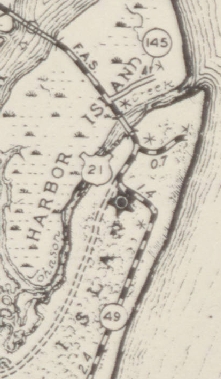
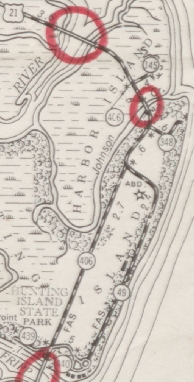
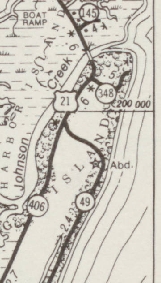
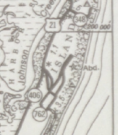
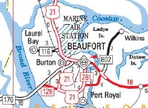
In 1954, US 21 south was extended from Beaufort to Hunting Island, replacing SC 285. US 21 ended at S-7-348, just onto Hunting Island.
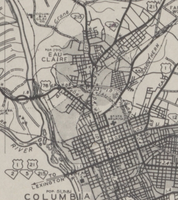
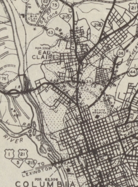
In 1954 or 1955, US 21 was rerouted in Columbia to continue south on Assembly to Blossom St before heading west across the Saluda River on the current US 21 bridge. The old route remained US 1-378 to West Columbia, then southward on Charleston Hwy became a bit of SC 602 with the rest becoming a US 1-21 connector. In 1957, US 21 south was extended to the Hunting Island Lighthouse along the oceanfront. Between 1958-67, US 21 was rerouted onto new alignment to avoid what is now the Eastman Chemical plant east of I-26 Exit 119.
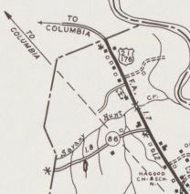
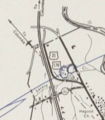
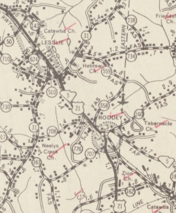
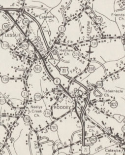
In 1965 (bridge date), US 21 was placed on newly constructed bypass of Lesslie, leaving behind S-46-6.
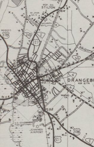
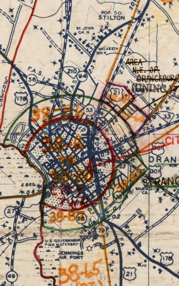
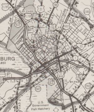
In 1967, US 21's bypass around Orangeburg was expanded to today's loop. Magnolia Avenue became US 21 Business.
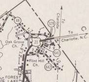
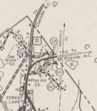
In 1968 or 1969, US 21 was rerouted to enter North Carolina where it does today with I-77. The old route heading to Pineville became the anomalous second SC 51.
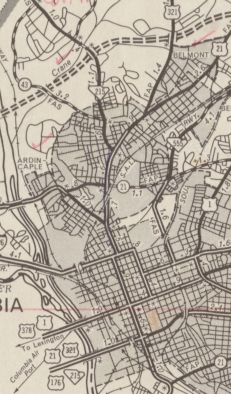
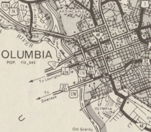
Between 1968-70, US 21 south was truncated inland back to S-7-145 on Harbor Island. The old route became S-7-406 onto Hunting Island and over to the lighthouse became S-7-49 (now most of this is abandoned or eroded away by the ocean). In 1978, US 21 was removed from Assembly St in Columbia and rerouted along Huger St like today. Assembly St became an extended SC 48.
Between 1977-80, US 21 was re-extended back over S-7-406 to the original entrance to Hunting Island State Park. Between 1981-86, US 21 south was extended south to the new (current) entrance to Hunting Island State Park, replacing a bit of S-7-406. The posting marking the current endpoint has never moved from the 1980 endpoint.
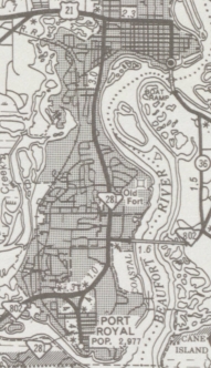
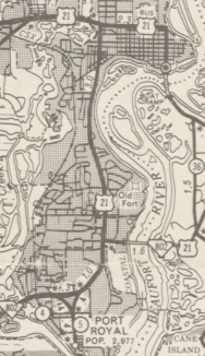
In 1990, US 21 was given a bypass of Beaufort, replacing SC 281 and multiplexing with SC 802. This left behind US 21 Business. In 2012, US 21's bypass of Beaufort was sent further southwest and around by Parris Island before meeting back up with US 21 at Burton, replacing SC 802 and SC 280. The old route via Ribaut Rd north back to US 21 went back to being SC 281.
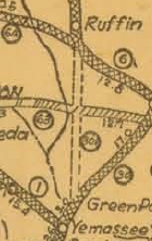
Improvements: Upon designation, US 21 was paved only from Columbia to Blythwood and from Smiths Turnout to Fort Mill. In 1928, US 21 was paved from Fort Mill to the NC Line and also around Orangeburg. In 1929, US 21 was paved from Smiths Turnout south to Blackstock; Columbia to Sandy Run; and also around St. Matthews. In 1931, US 21 was paved Blackstock to Simpson; Blythewood to Columbia; and from Sandy Run to St. Matthews. In 1932, US 21 became paved continuously from Branchville to the NC Line and around Ruffin. In 1935, US 21 was paved from Branchville to SC 64. The last piece of US 21 to be paved, SC 64 to Yemassee, occurred in 1938. The first piece of US 21 to be 4-laned was in place by 1937, from the current US 321 split north of Columbia to the US 1 split in West Columbia. In 1956, US 21 was 4-laned down to the US 321 south split in Dixiana. In 1957, US 21 was 4-laned on the north side of Rock Hill. In 1961, US 21 was 4-laned from SC 116 to Beaufort. About 1965, US 21 was 4-laned from the south end of the Rock Hill Bypass to the Chester County Line. In 1970, US 21 was 4-laned at the NC Line. In 1973, US 21 was 4-laned from Lobeco to SC 116. In 1975, US 21 was 4-laned from US 321 NB split to a mile or so past I-20. In 1980, US 21 was 4-laned from Lobeco to Gardens Corner. In 1990, US 21 Bypass of Rock Hill was 4-laned, as was the Beaufort Bypass south to SC 802 when designated. In 1995 or 1996, US 21 was 4-laned from 2 miles north of the Orangeburg Bypass south around to US 301 and also from the Orangeburg Bypass south 3 miles towards Rowesville. In 1997, US 21 was 4-laned on its US 17 multiplex. From 1998/1999 to 2014/15, US 21 is shown on official maps erroneously to be multilaned further north from Orangeburg to the Calhoun County Line. The extension of US 21 Bypass to Burton in 2012 was multilaned. Comment: US 21 carries little importance in South Carolina these days except to get to Beaufort. Most of US 21 today parallels either I-26 or I-77. The Orangeburg to Yemassee section is independent but hardly anyone drives this way. Although US 21 looks like it zig-zagged much more in its pre-1950 routing, its distance in 1948 was actually shorter than today's distance. | |||||||||||||||||||||||||||||||||||||||||||


Previous: US 17 |
Next: US 21 ALT | US 21 Bus | US 25
Top | South Carolina Hwy Index
Home
Page last modified 4 August 2017